A reservoir in Texas reached record-low levels this summer, with images from space capturing the staggering scale of its decline.
The Amistad reservoir, straddling the Texas-Mexico border on the Rio Grande, dropped to less than a quarter full in July this year, hitting a record low of 1,047.15 feet above sea level on July 17.
In images taken from the OLI (Operational Land Imager) on Landsat 8 and the OLI-2 on Landsat 9, NASA has revealed how the reservoir looked on August 5, 2016, compared to August 19, 2024—mere weeks after hitting the record-low—when water levels were at 1,048.64 feet. As of August 23, the reservoir is at 1,048.58 feet.
Drag slider compare photos
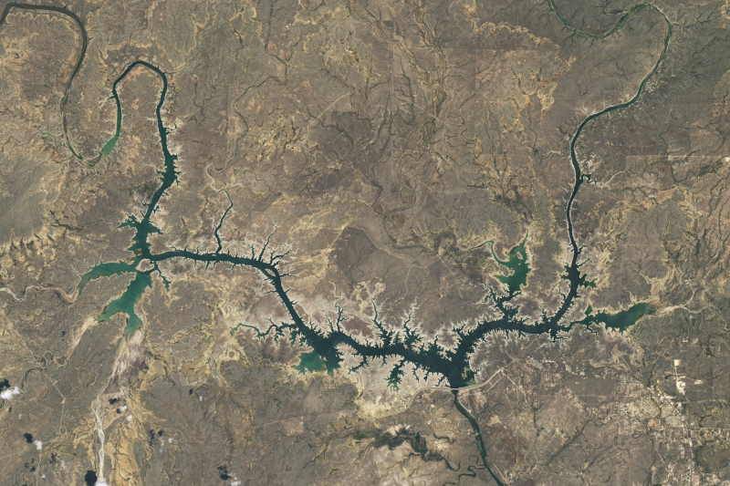
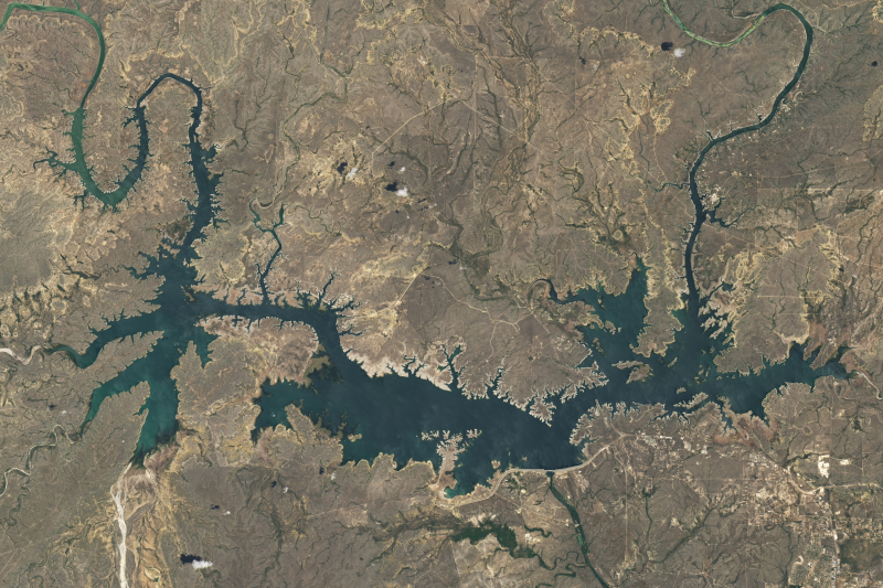
The previous record low was seen in August 2022, when the reservoir hit 1,052.48 feet. This year, the reservoir has been below 1,052 feet since February.
The Amistad was created with the construction of the Amistad Dam in 1969, and is a joint venture between the U.S. and Mexico to provide water and hydroelectric power to both countries.
Water levels in the Amistad, as well as the Falcon Reservoir—also on the Rio Grande between Texas and Mexico—have been dropping significantly in recent decades. The reservoir was consistently low between 1992 and 2002, hitting historic lows in 2013, 2022, and now again in 2021.
The primary cause of declining water levels at the Amistad Reservoir has been prolonged periods of drought in the region. Much of the Rio Grande Basin and Western Texas was under "severe," "extreme" and even "exceptional drought throughout this summer, with heat waves bringing temperatures as high as 112 degrees to Del Rio on August 21, 2024.
This drought has had the region in its grips for several years now, leading to water levels declining with every passing year. As of August 20, the U.S. Drought Monitor shows that the Amistad is under "severe" drought, and has been since March, entering into "extreme" drought briefly during June.
Resultant reduced rainfall and limited inflows from the Rio Grande and its tributaries have significantly lowered the reservoir's capacity, and rising water consumption for agricultural irrigation and urban needs in both the United States and Mexico has further strained the reservoir's scant supplies.
According to a recent report by the International Boundary and Water Commission (IBWC), which oversees the collaboration between Mexico and the U.S. at the Amistad, the reservoir saw 33 percent less water entering it between 2011 and 2020 compared to between 1981 and 1990.
"Experts estimate that a large part of this loss in flow we're seeing can be attributed to higher temperatures in the region, a result of human-caused climate change. This was not the case with previous comparable droughts (like in the 1950s), which were primarily caused by lack of precipitation. With climate change, temperatures are likely to continue to increase, exacerbating the risks for such prolonged droughts," Antonia Hadjimichael, an assistant professor in geosciences at Penn State University, previously told Newsweek.
Do you have a tip on a science story that Newsweek should be covering? Do you have a question about reservoirs? Let us know via science@newsweek.com.
Disclaimer: The copyright of this article belongs to the original author. Reposting this article is solely for the purpose of information dissemination and does not constitute any investment advice. If there is any infringement, please contact us immediately. We will make corrections or deletions as necessary. Thank you.