Egypt's historic capital, Cairo, is witnessing the end of an era. After serving as the nation's political center since the 10th-century C.E., the city is set to hand over the reins to a newly constructed settlement in the desert, about 28 miles to its east.
The Egyptian government announced this strategic move in 2015, driven by the need to address Cairo's swelling population, traffic congestion and pollution.
New satellite images from NASA's Landsat missions have captured the rapid development of the yet-to-be-officially-named "New Administrative Capital," a megaproject that promises to reshape Egypt's future. The new city will one day cover an area the size of Singapore and host more than 6 million residents.
Drag slider compare photos
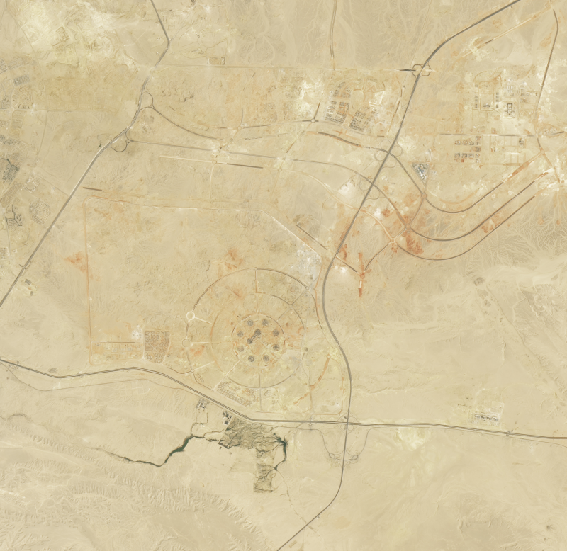
The images, taken by the Operational Land Imager (OLI) on Landsat 8 in August 2017 and the OLI-2 on Landsat 9 in August 2024, show the city's transformation from a nascent construction site to a soon-to-be sprawling urban center.
In the earlier image, taken in 2017, traces of the new city are barely visible. However, by 2024, the expansion of the New Administrative Capital is unmistakable, with several significant landmarks clearly discernible.
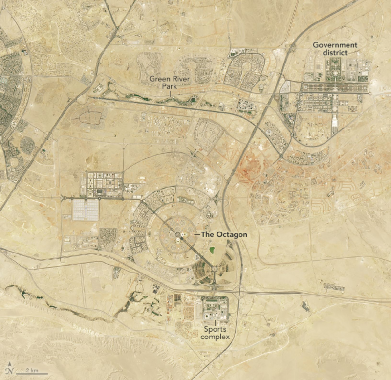
Among these is the Green River Park, a 10-kilometer [6.4-mile] stretch of green space weaving through the arid landscape, featuring walking and cycling paths amid native Egyptian vegetation.
To the east of the park, a dense cluster of government ministry offices has taken shape, while the Ministry of Defense now occupies a massive facility known as The Octagon.
Southward lies a sprawling sports complex, home to Africa's second-largest stadium and numerous other facilities, as Egypt eyes a bid to host the Olympics in 2036.
As of March 2024, over 1,500 families had already relocated to the New Administrative Capital, with projections indicating that number could reach 10,000 by the end of the year.
Government ministries have begun operations in their new premises; the Parliament has convened in its state-of-the-art building, and several banks and businesses are set to move their headquarters to this modern hub.
The decision to build this new capital comes as Cairo's population continues to surge. Estimates in 2024 placed the city's population at over 22 million, with a density of more than 50,000 people per square mile—the 37th highest in the world.
This rapid growth, which has nearly tripled Cairo's population since 1984, has significantly altered the city's footprint, pushing development outward along the Nile River and into the desert plains.
Cairo's transformation has been closely monitored from space since 1965, with NASA's Gemini 5 mission documenting the city's early urban sprawl.
The more-recent Landsat images not only showcase the emergence of the New Administrative Capital but also highlight the extensive urban expansion in greater Cairo over the past four decades.
The growth is placing immense pressure on Egypt's resources, particularly the Nile River, which supports about 95 percent of the country's population.
With increasing demands from both domestic and agricultural sectors, studies have shown that Egypt may soon face a significant water deficit, potentially requiring the country to import more water than is supplied by the Nile by the end of the decade.
Do you have a tip on a science story that Newsweek should be covering? Do you have a question about sustainable cities under construction? Let us know via science@newsweek.com.
References
Nikiel, C. A., & Eltahir, E.A.B. (2021). Past and future trends of Egypt's water consumption and its sources. Nature Communications, 12(1), 4508. https://doi.org/10.1038/s41467-021-24747-9
Disclaimer: The copyright of this article belongs to the original author. Reposting this article is solely for the purpose of information dissemination and does not constitute any investment advice. If there is any infringement, please contact us immediately. We will make corrections or deletions as necessary. Thank you.