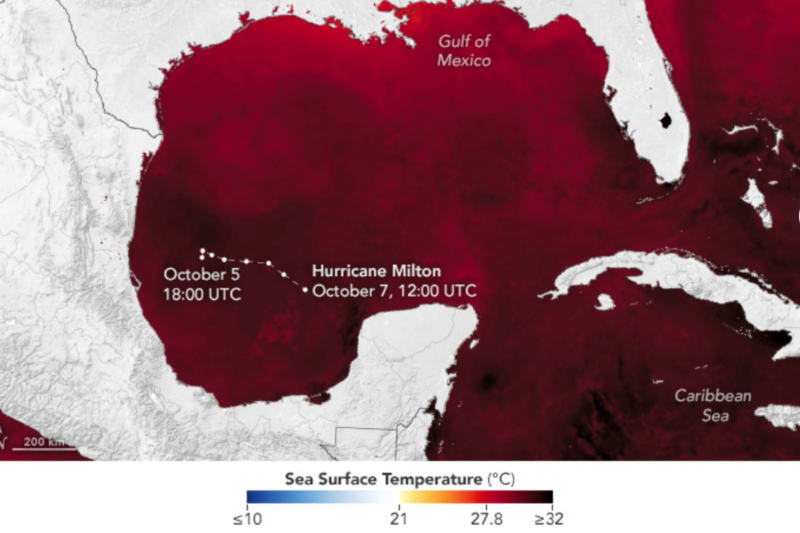
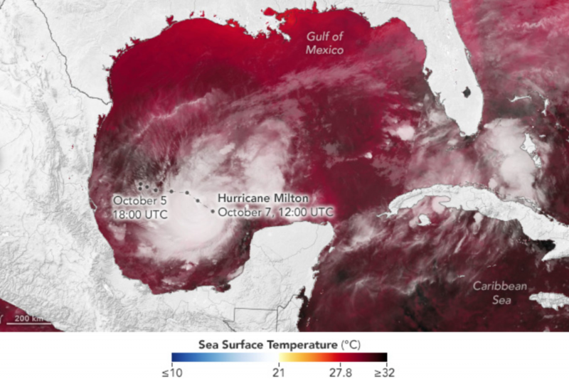
NASA images have captured the unique ocean conditions that allowed Hurricane Milton to intensify so quickly to a Category 5 tempest on its approach to the Florida coast.
Milton developed in the western Gulf of Mexico from an area of low pressure which developed into a tropical depression, strengthening into a tropical storm on Saturday and hitting hurricane strength on Sunday evening.
The storm then intensified phenomenally quickly on Monday, leaping to a Category 5 hurricane with 180 mph winds by Monday afternoon.
The images show the sea surface temperatures across the Gulf of Mexico on October 6 and 7, recorded by the Short-term Prediction Research and Transition (SPoRT) at NASA's Marshall Space Flight Center.
The entire Gulf can be seen to be above 82 degrees F—the temperature needed sustain and intensify hurricanes—and regions colored the darkest red are warmer than 89.6 degrees F.
Drag slider compare photos


The warmer the sea surface, the easier it is for storms and hurricanes to intensify.
Milton was also aided in its rapid intensification by low wind shear, as this allows storms to quickly build in speed and power.
The images also show Milton's path through the Gulf, and its position on October 7, snapped by the VIIRS (Visible Infrared Imaging Radiometer Suite) on the NOAA-21 satellite.
According to NOAA, Milton increased its wind speeds by 95 mph—from 80 to 175 mph—during a single 24-hour period, a feat only seen before with Wilma in 2005 and Felix in 2007.
"Numerical models in the past five years or so have improved to resolve hurricanes and typhoons at global scales and they do agree that the intensification of hurricanes (more hurricanes of strength 4 or 5) and typhoons, and a tendency for depression to turn more easily into hurricanes is the result of climate change," Annalisa Bracco, a professor of ocean and climate dynamics at the Georgia Institute of Technology, told Newsweek.
"We do expect to see more often than we used to the rapid intensification of tropical cyclones because of the warming that the tropical oceans are experiencing."
Milton is the second Category 5 Atlantic hurricane this year, after Beryl in July, and is the fifth most powerful Atlantic hurricane in recorded history by central pressure, and tied for the third-strongest hurricane in Atlantic history by wind speed.
"There have only been five other years (since 1950) in which there were more than one Category 5 hurricane in a single season; 1961 (2), 2005 (4), 2007 (2), 2017 (2), and most recently 2019 (2)," NOAA explained.
Milton currently has wind speeds of 155 mph, having just dropped back down to Category 4 strength. The hurricane is forecast to bring up to 15 feet of storm surge to some regions of the coast, and as much as 18 inches of rain to certain areas.
"Damaging winds, life-threatening storm surge, and heavy rainfall will extend well outside the forecast cone. This is a very serious situation and residents in Florida should closely follow orders from their local emergency management officials," the NHC said in a forecast advisory.
"Evacuations and other preparations should be rushed to completion. Milton has the potential to be one of the most destructive hurricanes on record for west-central Florida."
Thousands of people have been advised to evacuate across the state, especially in the Tampa Bay area and others in the path of the storm.
"Hurricane winds grab people's attention, but flooding is probably the biggest concern with Milton. Winds of 150mph can easily destroy buildings and cause injuries and fatalities if people are caught out in the open by flying debris," Hannah Cloke, a professor of hydrology at the University of Reading, said in a statement.
"There are three types of floods that cause the biggest damage—storm surge causing coastal flooding, flash floods from the extremely heavy rain, and river floods as all that water rushes down channels and onto floodplains."
Do you have a tip on a science story that Newsweek should be covering? Do you have a question about hurricanes? Let us know via science@newsweek.com.
Disclaimer: The copyright of this article belongs to the original author. Reposting this article is solely for the purpose of information dissemination and does not constitute any investment advice. If there is any infringement, please contact us immediately. We will make corrections or deletions as necessary. Thank you.


